Ride Statistics
Ride Difficulty Rating: Beginner but can be used as a longer early season training ride
Distance: up to 80 Km (out and back)
Estimated time: Up to 4 hours based on a cycling speed of 20 km/hr
Elevation Gain: 10m
Maximum Elevation: 1200m
Best Parking Option: Edworthy Park, Max Bell Arena, or the Bow Waters Canoe Club
Points of Interest: Chestermere Beach, Irrigation Canal, Golf Course
Amenities: Bathrooms are located at the end of the Bike path at Chestermere (Port O Potty) or at the Tim Hortons
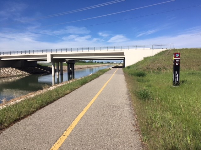
Pathway Condition:
There are many sections on this route that are very rough due to tree roots protruding and lifting the pathway pavement. Good news is that as of late July 2024 the pathway is finally getting some maintenance to remove some of these ‘natures speed bumps’. You can really get some nice speed up on this pathway so still use caution as not all tree roots have been removed.
When coming from Edworthy Park, there is poor (non-existent) signage that points you to the Canal Pathway so make sure you bring the Ride with GPS map with you. For example, it is easy to miss the Ped way that takes you over Deerfoot Trail. This fork in the pathway is just as you pass the Zoo and pass under the rail bridge and has a canal marker B13! Hope you don’t miss it!
Another tricky spot is just after passing the Max Bell Arena you need to cross over the irrigation canal using the 17 Ave bridge. It is easy to miss the fork in the pathway that takes you onto the bridge.
As you approach Chestermere Lake you will encounter a detour onto a short gravel pathway that takes you around some construction. (As of July 2024) Follow the signage and you will pop back onto the bike pathway in about 500 m.
Comments from our test riders:
Beginner Road Cyclist: I felt comfortable starting this route at the Bow Waters Canoe Club. I was able to increase my distance to 56 Km on the pathway without feeling pressured. I can use this route to condition myself to longer excursions.
Intermediate Road Cyclist: This is a great early season route to get some distance training in preparation for my longer rides. If you want to avoid the Deerfoot crossing there is another approach that some will find a lot more pleasant. Stay on the west side of the river, past the Inglewood bird sanctuary and cross the Bow at Ogden Road. Then stay on the bike path to 50th Ave SE then cross over Ogden and onto the canal path just after Ogden. This avoids Deerfoot altogether and also that section of the canal path that is rather tight underneath Deerfoot.
Expert Road Cyclist: I can depend on this pathway system to provide early season training for 80 Km or more if I connect to other city pathways.

What to expect from this ride
This ride connects Calgary to the bedroom community of Chestermere. It is very unique because from the Max Bell Arena to Chestermere you are following the irrigation canal. The canal is only a small portion of the Western Irrigation Districts 1200 Km of canals and pipelines. It provides irrigation water to over 400 farms and municipal water to four communities using a gravity drainage system that started in 1904 with the placement of the diversion weir on the Bow River in Calgary. You can access this ride from anywhere along the Bow River Pathway and the maximum length of ride is 80 Kilometres one way making this a very good early season training route for expert cyclists and a fun beginner ride any time of the year.
Although this route traverses some of the industrial areas of Calgary there is no denying the appeal of this long distance option early in the year. Once you reach the irrigation canal waters it is a very unique opportunity to savour a Spring ride along this channelled river. It makes sense to do this ride early since you are exposed to wind and weather that forms during the day. At the mid point, dip your feet into Chestermere Lake at Anniversary Park beach in Chestermere (or go for a swim) and you can pop into the Tim Hortons across the street for sustenance to fuel your return trip.


