2025 Note: Due to the G7 Summit Highway 40 from the North gate will only be open for cycling until May 31th. You can access Highway 40 from the South gate up to the Ptarmigan Cirque Parking Lot (which is very close to the Highwood Pass Summit) until June 20th. Highway 40 opens to motor vehicle traffic on June 21. Thanks to my co-worker Matthew for bringing this to cyclealberta’s attention.
Anyone who has cycled Highwood Pass has their preferred route and direction. Cycleaberta prefers coming at the pass from the Longview side, as we prefer a longer climb, slightly gentler grades and fewer cyclists. The road surface is also in better shape than the north gate to summit portion of the route. Approaching from the south will give you a better chance at cycling in the sunshine compared to from the Kananaskis gate approach. The Longview to Summit, South Gate to Summit out and back rides are the ones to try if you prefer to approach from the south…or if you live in south Calgary.
Through Route – South Gate to North Gate: An option is to ride a through route but this will take a commitment to either shuttle cars from Kananaskis and Longview or recruit two cycling groups, one group that starts at Kananaskis (north gate) and one that starts from Longview(south gate). Meet up in the middle at the summit and exchange car keys!!!
The North Gate (Kananaskis) to Summit ride is an out and back that we have seen all levels of cyclist..from small children, to e-bike riders to the most experienced road cyclist. The beauty of this ride is that there is room for everyone when the road is closed. Just take your time and you will make it to the summit. We have noticed that the pavement surface on this part of the route is not as good as coming from the south. Hopefully the province will use some of the funds they are collecting from the Kananaskis Pass to improve this road. One can only hope.
We have not done this ride when Hwy 40 is open to traffic but some cyclists we met on our recent trip up indicated that they would not recommend cycling this route when it is open to traffic as the condition of the shoulder is poor. Having said that, if you are an experienced cyclist there are many cyclists that do this route after the road is open. You will likely need to pull into the traffic lane on the descent. Ride safe and see our safety tips.
South Gate to Summit – Ride Statistics
This is our preferred route!!!!
Ride Difficulty Rating: Intermediate
Distance: 75.8 km
Estimated time: 3.5 hours based on cycling speed of 20 km/hr, but you might be quite a bit faster because there is quite a long descent on this route.
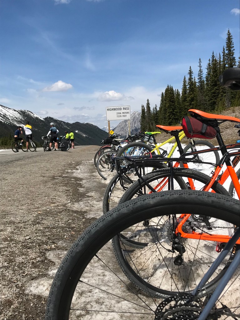
Maximum Elevation: 2,206 m
Grades: Uphill 5.8 % at 32.8 km, 5.0% downhill at 43.7 km
Use caution as there are several Texas gates!
Points of Interest:
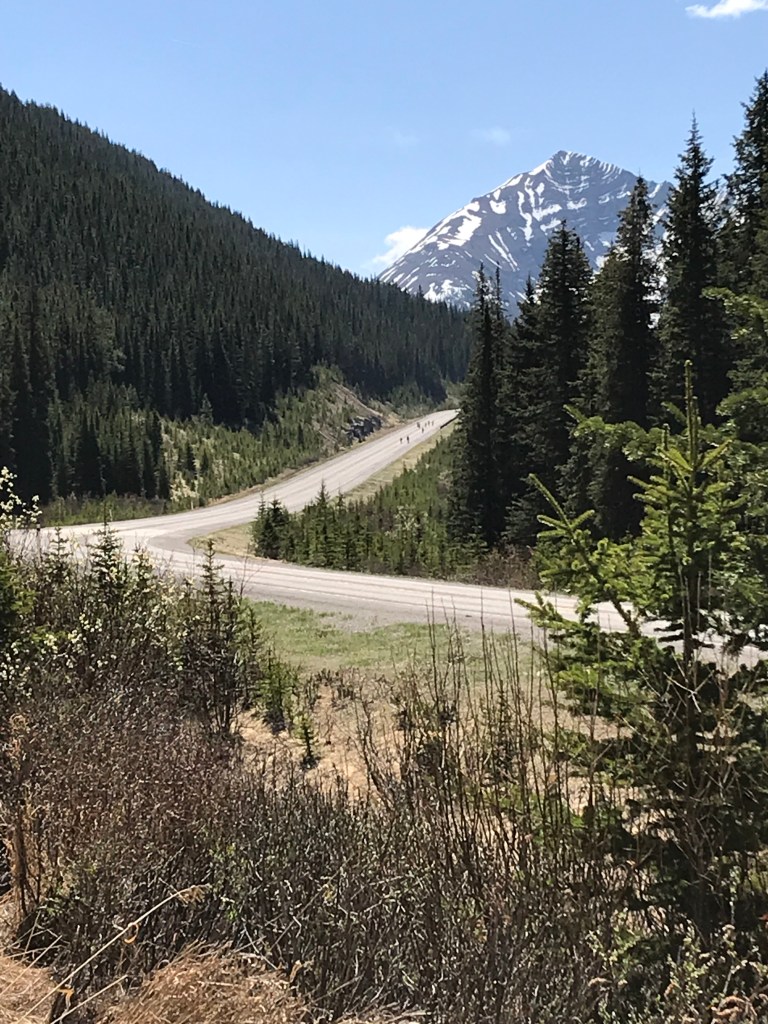
On your ascent you will be surrounded by beautiful mountain views. The summit is your destination.
Best Parking Option:
Drive to Longview, turn west on to Hwy 541. Proceed to the south gate which is at the Highwood House Junction. Park at the south gates. Pull off the road.
Amenities: there are no washrooms at the parking spot, but within the first 10 minutes or so of the route there are pit toilets at the first picnic spot that you will encounter.
Note: You will need to purchase a Kananaskis Conservation Pass to park here.
What to expect from this ride
Hwy 40 from the Peter Lougheed Provincial Park to Highwood House Junction is closed to motor vehicle traffic from Dec 1 – June 14th most years. This creates perfect early season road cycling opportunities along one of the most beautiful roads in Alberta. Highwood Pass is the highest paved pass in Canada..so a unique opportunity to get to this elevation on a road bike in Canada.
For updated details on Hwy 40 road closure, refer to the Annual Road Closure – Kananaskis.
First thing to mention on this epic ride is that you should remember that you are in the Rocky Mountains which means the possibility for rapidly changing weather conditions as you gain elevation. We did this ride on a beautiful, hot spring day in 2018. At the summit there was a strong cold wind. Without additional clothing to layer on for the descent made for a very uncomfortable ride…frozen hands and feet are not fun on a road bike. Although this makes a great early season ride because of the road closure, it also means that you may encounter snow on the road which might prevent you from reaching the summit. Don’t be disappointed, and come back a week later and conditions will have changed. Remember this is a closed road in the winter so is not plowed.
The second thing of importance is that this ride is along a paved mountain road. So the shoulder surface is different than the road surface. Because most cyclist ride here when the road is closed, you will ride on the road which is a rough, chip seal surface. This is fine on the ascent, but we find on the long descent this can make for quite a bit of handle bar vibration. As of June 3, 2021 we also noticed that the shoulder has become very rough.
A third item are the many Texas gates on the Longview side on these routes. We suggest dismounting and walking across, but have seen many a cyclist just ride across as though they are not even there.
Kananaskis (North Gate) to Summit – Ride Statistics
Ride Difficulty Rating: Beginner
Distance: 33.9 km
Estimated time: 1.75 hours based on cycling speed of 20 km/hr, but you might be quite a bit faster because there is quick descent on this route.
Elevation Gain: 622 m
Maximum Grade: 7.1 % uphill just before you reach the summit and of course 7.1% downhill on you quick return trip.
Maximum Elevation: 2,206 m
Points of Interest/Amenities:
Highwood Pass Summit at the 16.9 km mark. If you proceed just past the summit, there are washrooms and picnic tables.
Best Parking Option:
Park where Hwy 40 ends at the Kananaskis Lakes Trail turn off. Pull well off to the side of the road.
Through Route – South Gate to North Gate – Ride Statistics
Ride Difficulty Rating: Expert , also an expert level of logistics and planning required!!
Distance: 98.9 km…darn, just shy of a metric century ride
Estimated time: 5 hours based on cycling speed of 20 km/hr, but you might be quite a bit faster because there is quite a long descent on this route.
Elevation Gain: 785 m gain, 1255 m loss
Maximum Elevation: 2,206 m
Maximum Grade: 7.0 % uphill at 16.4 km (just before you reach the Highwood Summit, then 4.9 % downhill at 23 km.
Use caution as there are several Texas gates to cross over on Longview side.
Best Parking Option:
Park where Hwy 40 ends at the Kananaskis Lakes Trail (Peter Lougheed Provincial Park) turn off. As this is a through route, you will shuttle a car down to Longview and park in town. We recommend dropping a car off in Longview the night before, otherwise it will make for a long day of riding and shuffling cars.
Note: you will need to purchase a Kananaskis Conservation Pass in order to park here.
Gate to Gate to Gate (or Summit X 2) – Ride Statistics
Ride Difficulty Rating: Expert – this ride earns you bragging rights!
Distance: 109.7 km
Estimated time: 5 hours based on a 20 km/hr speed
Elevation Gain: 1,526 m
Maximum Elevation: 2,206 m
Grades: 7.1 % just before you reach the summit the first time, and of course 7.1% downhill just after you summit the second time.
Use caution as there are several Texas gates on the Longview side!
Points of Interest:
Highwood Pass Summit at the 16.9 km mark. If you proceed just past the summit, there are washrooms and picnic tables.
Bonus! Summit a second time on the return trip.
Amenities: There are several picnic stops along the way that have resting spots and pit toilets.
Park at either the north gate or south gate. The Ride with GPS map shows the route from the north Kananaskis gate.
Note: You will need to purchase a Kananaskis Conservation Pass in order to park at the north or south gate.
Longview to Summit – Ride Statistics
Ride Difficulty Rating: Expert
Distance: 162.2 km
Estimated time: 8 hours based on cycling speed of 20 km/hr, but you might be quite a bit faster because there is quite a long descent on this route. Nothing like putting in an honest 8 hour day!
Elevation Gain: 1,436 m
Maximum Grade: 5.8 % uphill at about km 76, and 5.0 % downhill at km 87
Use caution as there are several Texas gates on the Longview side!
Points of Interest:
As you depart Longview you will be treated with a long slow elevation gain through some lovely ranch country. You will be sharing the road with motor vehicle traffic until you get to the south gates at Highwood House Junction (Dec-June).
The Highwood Pass summit is your destination. Washrooms are just before you reach the summit and there are many pullouts and picnic stops along the way once you get past the south gates.
Best Parking Option:
Park in the town of Longview. Do not block any driveways.
Recommendation: Stop at the gas station in Longview (Fas Gas or Esso) or at the Longview Jerky Shop and pick up some of the famous Longview Beef Jerky. Highly recommended for the long ride ahead!